This page or template is currently under construction. When a page or template is under construction it means that all the information or details needed to make a full article isn't available. Please do not edit anything here without permission from an administrator until the construction is finished. Once the page is finished this template will be removed.
|
| 2009 Biolixi Ocean hurricane season | |
|---|---|
 Season Summary | |
|
First Storm Formed: |
June 11 |
|
Last Storm Dissipated: |
November 8 |
|
Strongest Storm: |
Kara - 898 mbar 180 mph |
|
Total Systems: |
22 |
|
Named Storms: |
21 |
|
Hurricanes: |
12 |
|
Major Hurricanes: |
6 |
|
Total Fatalities: |
No information |
|
Damage: |
No information |
|
Other Seasons: |
|
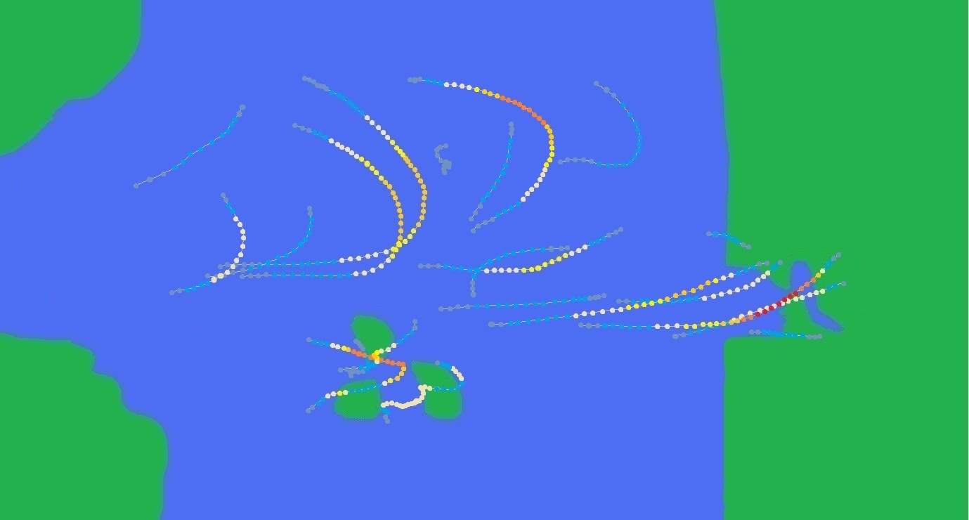
The 2009 Biolixi Ocean hurricane season started on June 11 with the formation of Tropical Storm Arlene which formed far from land. On June 18, Bonnie with the first tropical cyclone to affect land, causing 7 million simoleons in damage to the Biolixi Islands. June in all only produced 3 systems, one of them being a hurricane. On July 12, Hurricane Daniel became the first major hurricane of the season, also the second largest tropical cyclone on record. July produced six systems, two of which being major hurricanes. July was also tied with September for the most active month of the season. The season moved on into August which produced four systems, three of them being disastrous systems. Hurricane Ivan, which formed on August 6, was a very deadly system that caused 37.9 billion simoleons in damage, the most destructive hurricane in Biolixi Islands history. Right after Ivan affected the area, the deadly Hurricane Loran killed around 3,000 people, most of them homeless after Ivan's damage. San Francisco also experienced a destructive system, that system being Hurricane Kara, the originally reigning most destructive cyclone in history. Kara caused 137 billion simoleons in damage and caused 1,378 deaths. At the end of August and into September, the long lasting Hurricane Max caused severe flooding to the Eastern Biolixi Island. The month of September produced six systems, tied with July for the most active month of the season. October only produced three systems, two of which being major hurricanes. The season ended with the dissipation of Hurricane Wanda on November 8. The season as a whole caused (N/A) simoleons in damage and caused (N/A) deaths.
Seasonal Forecasts[]
The National Hurricane Center in Clark City predicted it to be a very acive season with around 19 named storms, 8 hurricanes, and 5 major hurricanes.
Actual Numbers:
Named Storms: 21
Hurricanes: 12
Major Hurricanes: 6
Storms[]
Timeline of Events[]

Tropical Storm Arlene[]
| Tropical storm (SSHS) | |||
|---|---|---|---|
| |||
| Duration | June 11 – June 15 | ||
| Intensity | 65 mph (100 km/h) (1-min), 994 mbar (hPa) | ||


On June 9, a tropical disturbance developed to the west of the Roanoke coast. The tropical wave moved towards the east and began to slowly develop over unusually warm waters. On June 11, the tropical disturbance was upgraded to the first system of the 2009 season, Tropical Depression One. One slowly moved to the east towards the Roanoke coast and intensified into the first named storm of the season, Tropical Storm Arlene. Arlene's first projected path was to potentially make landfall as a hurricane on the Roanoke coast, but due to a dip in the jet stream near the coast, Arlene began to be pulled to the north. On June 13, Arlene gained its peak intensity of 65 mph and minimum pressure of 994 mbar. Arlene continued to the north and slowly weakened as it met cooler waters. On June 14, Arlene began to be pulled slightly to the northwest and soon became subjected to moderate shear. During the late evening hours on June 14, Arlene weakened into a tropical depression with 35 mph winds. The next day, Arlene dissipated after becoming completely absorbed by the jet stream. Arlene caused no known affect to any land mass.
Tropical Storm Bonnie[]
| Tropical storm (SSHS) | |||
|---|---|---|---|
| |||
| Duration | June 18 – June 20 | ||
| Intensity | 45 mph (75 km/h) (1-min), 1000 mbar (hPa) | ||


Main Article: Tropical Storm Bonnie (2009)
On June 16, a tropical disturbance developed to the north of the Southern Biolxi Island. The tropical disturbance remained stationary as it slowly developed right off the northern coast of the island. Due to the system staying close to the coast for so long, heavy rain and some gusty winds were reported along the northern coast. On June 18, the tropical disturbance finally developed into a tropical depression with 35 mph winds. Shortly after being named a tropical depression, Tropical Depression Two began to slowly move to the north and then to the east. The size of the tropical depression caused widespread problems to the Southern Biolixi Island and the Northern Biolixi Island. Heavy rain, flooding, and gusty winds were reported throughout areas affected by the system; up to 11 inches of rain was reported along the northern coast of the Southern Biolixi Island. On June 19, the tropical depression strengthened into Tropical Storm Bonnie. Bonnie slowly moved to the north, towards the southwestern coast of the Northern Biolixi Island. After maintaining a peak intensity of 45 mph, Bonnie weakened into a tropical depression on June 20. Soon Bonnie became exposed to shear and began to move to the northwest up the Northern Biolixi Island coast. Bonnie dissipated during the evening hours of the same day. Bonnie caused widespread flooding throughout both of the islands, river banks were overtopped in some areas. Bonnie in all caused around 7 million simoleons and caused 9 deaths.
Hurricane Calvin[]
| Category 1 hurricane (SSHS) | |||
|---|---|---|---|
| |||
| Duration | June 25 – June 29 | ||
| Intensity | 90 mph (150 km/h) (1-min), 974 mbar (hPa) | ||


Main Article: Hurricane Calvin (2009)
On June 22, a tropical wave developed to the northeast of the Biolixi Islands. The wave quickly moved towards the east and began to slowly develop. On June 25, the tropical wave fully developed into Tropical Depression Three to the southwest of the San Francisco Gulf. Due to the favorable conditions provided, Three strengthened into Tropical Storm Calvin during the same day. On June 26, Calvin entered the San Francisco Gulf just a couple hundred miles off the coast of the southern Gulf coast. Calvin soon was a strong tropical storm and then strengthened into a category 1 hurricane on June 27. Hurricane Warnings and Watches were issued all along the San Francisco Peninsula. Due to Calvin only being a category 1 hurricane, many people along the coast ignored the warning is it drew closer. On June 28, Calvin gained its peak intensity of 90 mph and minimum pressure of 974 mbar. During the same day, Calvin weakened slightly, and made landfall near the city of Tree Beach with 85 mph winds. Calvin caused severe damage to the northern half of the the peninsula due to its very large size. Severe wind damage and catastrophic flooding was reported in the area as Calvin crossed the peninsula as a category 1 hurricane. On June 29, Calvin emerged into the San Francisco Bay and slightly strengthened and then made a second landfall near the city of Kentaro. Even more wind and flooding damage was reported as Calvin made landfall and then rapidly weakened. During the evening hours of June 29, Calvin continued to weaken as a tropical storm over land. Calvin weakened into a tropical depression for only two hours, and then completely dissipated far inland. Calvin caused around 865 million simoleons in damage and caused 17 deaths.
Hurricane Daniel[]
| Category 3 hurricane (SSHS) | |||
|---|---|---|---|
| |||
| Duration | July 8 – July 16 | ||
| Intensity | 125 mph (205 km/h) (1-min), 940 mbar (hPa) | ||


Main Article: Hurricane Daniel (2009)
On July 5, a tropical disturbance developed along the Tropical Cyclone Formation Axis. The tropical wave slowly organized over time and and began to enter an increasingly favorable environment. On July 8, the large tropical disturbance developed into Tropical Depression Four. Four slowly moved towards the east and gradually strengthened as it moved over warmer waters. On July 9, Four strengthened into Tropical Storm Daniel with 45 mph winds. Daniel continued on its path to the east and gradually intensified. On July 10, Daniel fully developed into the season's second hurricane as it began to curve to the east-northeast. Daniel then began to increase in size due to gaining access to a warm moisture flow to its southwest. Daniel gradually drew in the moisture which added on to its outer bands, increasing the hurricane's size. Daniel became the fifth largest tropical cyclone on record after strengthening into a category 2 hurricane on July 11. Daniel was predicted to become the world's largest tropical cyclone on record if it became any stronger than a category 4 hurricane. On July 12, Daniel became the season's first major hurricane with 115 mph winds. After becoming a stronger system, Daniel increased in size and became the world's second largest tropical cyclone on record. On July 13, Daniel gained its peak intensity of 125 mph and minimum pressure of 940 mbar. Afterwards, Daniel gradually weakened and decreased in size. On July 14, Daniel weakened into a category 1 hurricane after meeting much colder waters. On July 15, Daniel weakened into a tropical storm, and then a tropical depression during the evening hours. During the afternoon hours, Daniel dissipated. The only reported impacts from Daniel were very strong surf and dangerous rip currents.
Hurricane Edna[]
| Category 3 hurricane (SSHS) | |||
|---|---|---|---|
| |||
| Duration | July 15 – July 22 | ||
| Intensity | 120 mph (195 km/h) (1-min), 947 mbar (hPa) | ||


On July 13, a tropical wave developed along the Tropical Cyclone Formation Axis. The wave quickly met warmer waters and began to rapidly intensify on July 14. On July 15, the tropical wave was upgraded to Tropical Depression Five. Five slowly moved towards the east and quickly strengthened into Tropical Storm Edna the next day. Edna soon began to encounter some unfavorable conditions to its north. Dry air began to interact with the system's center which then exposed it. On July 17, Edna began to re-organized which triggered and eye-wall replacement cycle, even though the system was only a tropical storm. During the afternoon hours, Edna became a category 1 hurricane and began to be pulled to the east-northeast. Edna slowly intensified over time as it met more and more favorable conditions. On July 19, Edna became the season's second major hurricane of the year with 115 mph winds. Unlike Hurricane Daniel of earlier that year, Edna was in much smaller size. This decreased the chances of Edna rapidly strengthening in an area of slight wind shear, in which Daniel was able to push through due to its size. Edna began to weaken and began to meet even stronger wind shear. On July 21, Edna weakened into a tropical storm after its center had become completely exposed. Edna then weakened into a tropical depression and then dissipated on July 22. No impacts were reported from Edna.
Hurricane Frank[]
| Category 2 hurricane (SSHS) | |||
|---|---|---|---|
| |||
| Duration | July 20 – July 25 | ||
| Intensity | 105 mph (165 km/h) (1-min), 978 mbar (hPa) | ||

On July 17, a tropical wave began to develop off the eastern coast of the Northern Biolixi Island. The tropical wave remained stationary off the island's coast, which brought some light impacts such as heavy rain and rip currents. On July 18, the tropical disturbance was finally pushed away to the east by a cold front, which then helped it develop. On July 19, the disturbance entered open warm water with little wind shear, which in turn help it rapidly develop. On July 20, the disturbance finally developed into Tropical Depression Six with 35 mph winds. Six continued to the east and continued to develop in the favorable conditions. During the evening hours of July 20, Six developed into Tropical Storm Frank. On July 21, Frank began to develop a slight eye near its center which gave the National Hurricane Center and idea that Frank was rapidly intensifying, triggering a water transportation hazard advisory to many coastal areas that pass through Frank's projected path. During the evening hours of July 21, Frank intensified into a category 1 hurricane with 75 mph winds. On July 22, Frank was upgraded to a category 2 hurricane where it gained its peak intensity of 105 mph. On July 23, Frank began its weakening process as it moved over a more unfavorable area. Frank weakened into a category 1 hurricane during the evening hours of July 23, and then into a tropical storm on July 24. Frank continued its weakening and became a tropical depression on July 25. Frank dissipated the same day.
Tropical Storm Gloria[]
| Tropical storm (SSHS) | |||
|---|---|---|---|
| |||
| Duration | July 27 – July 29 | ||
| Intensity | 50 mph (85 km/h) (1-min), 1002 mbar (hPa) | ||


Main Article: Tropical Storm Gloria (2009)
On July 25, a tropical wave was spawned from a cold front that formed a few hundred miles off the coast of Roanoke. The wave began to quickly develop as the shearing cold front moved to its north instead of staying behind it. On July 27, the tropical disturbance gained winds of 35 mph and was titled Tropical Depression Seven. Seven intensified very quickly since it was in very warm coastal waters. Seven became Tropical Storm Gloria during the evening hours of July 27. Gloria quickly grew in size and began to bring very heavy rain and gusty 50 mph winds to the coast of Roanoke. Roanoke's largest city, Roanoke, reported that over 4 and a half inches had fallen after only 4 hours after it was named Gloria. On July 28, Gloria made landfall at the same time it gained its peak intensity of 50 mph and minimum pressure of 1002 mbar. Gloria then moved inland and began to quickly weaken from the cold from it formed from to its east. On July 29, Gloria weakened into a tropical depression and then dissipated after moving over 80 miles inland. Gloria caused and estimated 11 million simoleons in damage and caused 2 fatalities.
Tropical Storm Hillary[]
| Tropical storm (SSHS) | |||
|---|---|---|---|
| |||
| Duration | July 30 – August 2 | ||
| Intensity | 60 mph (95 km/h) (1-min), 994 mbar (hPa) | ||

On July 25, a vigorous tropical wave developed to the west of the Biolixi Islands. The tropical wave headed quickly towards the east and crossed the Biolixi Islands throughout the 24 to 29. On July 30, the tropical wave became very organized and became Tropical Depression Eight. Eight intensified very quickly during the same day it was titled and was soon nearing tropical storm status. On July 31, Tropical Depression Eight became Tropical Storm Hillary with 40 mph winds, a minimal tropical storm. Hillary began to merge with a large line of tropical activity that ranged from the Biolixi Islands to Roanoke. Hillary traveled the same direction the flow of the line of storms was going, to the east-northeast. Hillary became very shrouded in the mitts of all the tropical activity around, this caused slight shear to the system as it continued to try and strengthen. On August 1, Hillary gained its peak intensity of 60 mph and minimum pressure of 994 mbar, since the system was too sheared to attain a hurricane status. On August 2, Hillary rapidly deteriorated and began to slow down. Hillary weakened into a tropical depression, and then to a remnant low as its center became completely exposed. Only heavy rain from its pre-courser low was the only impacts to the Biolixi Islands as the wave passed through. No severe damage or deaths were reported.
Tropical Depression Nine[]
| Tropical depression (SSHS) | |||
|---|---|---|---|
| |||
| Duration | July 30 – August 1 | ||
| Intensity | 35 mph (55 km/h) (1-min), 1004 mbar (hPa) | ||


On July 28, a tropical wave began to organize to the north of the Biolixi Islands. The wave began to move to the north and slowly intensified over warm waters. On July 30, the National Hurricane Center gave the system a near one-hundred percent chance of development as its center of circulation became more well-defined. Later that day, new advisories were being issued on Tropical Depression Nine as the system strengthened. Nine moved very slowly to the north due to being locked in a pocket of non-flowing air. The system was expected to become a tropical storm due to being over warm waters for a long amount of time. Before Nine had the chance to develop into a tropical storm, the pocket of non-moving air was broken open by a strong cold front to its west. The cold front quickly began to pull Nine towards the west-northwest and began to shear the system severely. On August 1, Nine's center of circulation became completely exposed causing the system to dissipate. No impacts from the system were reported.
Hurricane Ivan[]
| Category 4 hurricane (SSHS) | |||
|---|---|---|---|
| |||
| Duration | August 6 – August 11 | ||
| Intensity | 155 mph (250 km/h) (1-min), 926 mbar (hPa) | ||


Main Article: Hurricane Ivan
On August 4, a vigorous tropical disturbance developed off the southwest coast of Southwest. The wave began to move to the northeast towards Southwest and rapidly developed over the warm coastal waters. On August 6, the tropical disturbance developed into Tropical Depression Ten off the coast of Southwest. Ten quickly intensified over the warm ocean temperatures and became Tropical Storm Ivan during the evening hours of August 6. Ivan continued to intensify as it drew closer to the coast of Southwest. On August 7, Ivan became a category 1 hurricane off the coast of the island with 85 mph winds, and was still rapidly intensifying. During the evening hours, Ivan became a category 2 hurricane with 100 mph winds right before it made landfall in Southwest. Ivan's landfall caused severe damage along the populated coast. Ivan also caused severe damage with flooding rain as it crossed the island as a tropical storm, causing around 1 billion simoleons in damage. On August 8, Ivan emerged back out over water in the Biolixi Bay. As Ivan met the very warm watered favorable area, it began to rapidly intensify for the second time in its lifespan. Ivan rapidly became a category 3 major hurricane on August 9 just off the coast of the Eastern Biolixi Island causing some severe damage along the very northwestern coast. After causing damage to the northwestern part of the Eastern Biolixi Island, Ivan began to quickly be pushed to the northwest from a rapidly strengthening frontal boundary to its east. Due to the moisture being brought from the frontal boundary, Ivan continued to rapidly intensify, but in a much faster pace. Ivan became a category 4 hurricane during the evening hours of August 9. From there, Ivan quickly raced to the northwest triggering very serious evacuation orders along the southern Northern Biolixi Island coast around the city of Utopia City. On August 10, Ivan makes the most devastating landfall that the Northern Biolixi Island has ever had. Ivan causes extreme damage around the evacuated areas of the island. Ivan's storm surge was measured around 15-27 feet in some areas. After landfall, Ivan rapidly weakend as it met an area of dry air. Ivan weakened into a tropical storm, then to a tropical depression, and then to dissipation all on August 11. Ivan caused an astounding 37.9 billion simoleons in damage and caused 113 deaths, making Ivan the most devastating system to the Northern Biolixi Island in history.
Hurricane Jackson[]
| Category 1 hurricane (SSHS) | |||
|---|---|---|---|
| |||
| Duration | August 14 – August 18 | ||
| Intensity | 85 mph (140 km/h) (1-min), 979 mbar (hPa) | ||

Main Article: Hurricane Jackson (2009)
On August 10, a tropical disturbance began to develop to the northeast of the Northern Biolixi Island. The disturbance began to move to the east and started to gather organization as found warmer waters. On August 14, the tropical disturbance developed into Tropical Depression Eleven about 700 or so miles southwest of the northern coast of Gulf. Eleven continued to move to the east and continued to gather strength as well. Around the evening hours of August 14, Eleven developed into Tropical Storm Jackson with 45 mph winds. After Eleven developed into Tropical Storm Jackson, it began to encounter some slight wind shear, which delimited the possibility of rapid intensification as it moved towards the San Francisco Gulf. On August 16, Jackson intensified into category 1 hurricane with 75 mph winds after it had left the patch of moderate wind shear. During the evening hours of August 16, Jackson entered the San Francisco Gulf; this triggered hurricane warnings and optional evacuation orders along the northern Gulf coast. On August 17, Jackson became a very large category 1 hurricane with 85 mph winds and minimum pressure of 979 mbar. Due to Jackson's large size, some mandatory evacuations were ordered around the area where landfall was expected. During the evening hours of August 17, Jackson made landfall with 80 mph winds, causing severe damage to many homes that were along coastal areas of that region. Severe flooding was also present, especially further inland where Jackson weakend to a tropical storm. On August 18, Jackson weakened into a tropical depression and then dissipated after becoming completely disorganized by the mountainous terrain. Jackson caused an estimated 312 million simoleons in damage and caused 6 deaths. Even though Jackson caused severe damage, it was not retired on November 30.
Hurricane Kara[]
| Category 5 hurricane (SSHS) | |||
|---|---|---|---|
| |||
| Duration | August 17 – August 23 | ||
| Intensity | 180 mph (285 km/h) (1-min), 898 mbar (hPa) | ||


Main Article: Hurricane Kara
On July 15, a tropical wave began to develop in the southern half of the Biolixi Ocean near the Biolixi Islands. The wave moved eastward and quickly began to organize over warm waters. On July 17, the tropical disturbance finally developed into Tropical Depression Twelve. Twelve rapidly developed as is continuously met a more and more favorable environment. On July 18, Twelve was upgraded into Tropical Storm Kara about 950 miles west of the San Francisco Gulf. Gradually over time, Kara strengthened into a strong tropical storm. On July 19, Kara became a category 1 hurricane with 80 mph winds as it drew closer to the San Francisco Gulf. Finally, during the evening hours of July 19, Kara entered the San Francisco Gulf as a major hurricane with 115 mph. After Kara entered the gulf at that intensity, major watches and warnings were issued along the San Francisco Peninsula as the threat of an impact there grew. The National Hurricane Center advised many people who lived in San Francisco to bare for the worst of what Kara could offer as it moved closer to the coast. On July 20, Kara became a category 4 hurricane with 150 mph winds. Around the same time it strengthened, Kara also began its expected curve to the northeast towards the city of Cliff Mesa Pass. During the evening hours of July 20, Kara became a category 5 hurricane with 175 mph winds. This triggered extreme precaution advisories from the Governor of San Francisco to tell everyone who lives on the peninsula to immediately get out of harms way. The National Hurricane Center documented in extreme detail on how Kara gained its very intense peak intensity of 180 mph and minimum pressure of 898 mbar. When Kara gained its peak intensity, impacts were beginning to be felt across the entire peninsula, including some parts of Gulf and Virginia. During the evening hours of July 21, Kara made its closest approach to land, about 7 miles off the coast of the city Cliff Mesa Pass, causing extreme damage. After Kara had left the tip of the peninsula, it weakened back into a category 4 hurricane and made another intense landfall near the city of Jackele in northern San Francisco, also causing extreme damage. On July 22, Kara weakened into a tropical storm as it met high terrain further inland. On July 23, Kara dissipated as a tropical depression to the northwest of the city of Francisco. Damage from Hurricane Kara was immense, ranging into the 120 billions. On September 21, when the official total was released, Kara had over-topped expected predictions. Kara in all caused 137 billion simoleons in damage and caused 1,378 deaths. At the time, Kara was the most destructive and damaging storm in San Francisco history, until Hurricane Sydney of 2010 caused around 190 billion simoleons in damage, breaking Kara's record. As expected, the name "Kara" was retired on November 30, 2009 during the NHC Conference and was replaced by "Kathy" for the 2016 season.
Hurricane Loran[]
| Category 3 hurricane (SSHS) | |||
|---|---|---|---|
| |||
| Duration | August 25 – August 28 | ||
| Intensity | 120 mph (195 km/h) (1-min), 954 mbar (hPa) | ||


Main Article: Hurricane Loran
On August 23, a tropical wave began to develop to the northwest of the Southern Biolixi Island. The wave moved eastward and met very warm waters where it began to quickly organize. On August 25, the disturbance became Tropical Depression Thirteen and began to affect the southwest coast of the Northern Biolixi Island. During the evening hours of August 25, Thirteen became Tropical Storm Loran with 50 mph winds, about 25 miles off the coast of the Northern Biolixi Island. After being deemed a tropical storm, Loran began to bring heavier rains and stronger winds to the Southern and Northern Biolixi Island. Tropical Storm Warnings and Watches were posted on every island in the Biolixi Islands. On August 26, the National Hurricane Center began to issue hurricane warnings along the southern coast of the Northern Biolixi Island. The warm water temperatures and favorable conditions triggered a rapid intensification process in Loran, one of the quickest intensifications in history. The director of hurricane evacuations and routes for the Biolixi Islands told residents to not ignore Loran as it approached the coast of the Northern Biolixi Island. He also told them not to panic or wait until the last minute as Loran could bring more devastation to the already ravaged area by Hurricane Ivan about a month prior to Loran. During the evening hours of August 26, Loran rapidly intensified into a category 1 hurricane wiht 85 mph winds. Because of this, more and more people began to evacuate area that Loran was affecting. On August 27, Loran intensified into a major hurricane with 120 mph winds, causing extreme damage to the already heavily damaged areas by Ivan. The National Hurricane Center knew that Loran would be a very nasty system due to the large inland eye it had after moving inland over the city of Utopia City. After landfall, Loran quickly began to deteriorate over the high elevations, weakening it to a category 1 hurricane. But due to the size and strength of Loran, it continued to remain a category 1 hurricane as it move over land to the northeast. On August 28, Loran moved back out over open water and weakened into a tropical storm due to becoming completely torn apart. During the evening hours of August 28, Loran weakened into a tropical depression and then became extra-tropical after merging with a cold front. Loran caused a lot less damage since Hurricane Ivan already had ravaged the coastline. But the deaths from Loran were much higher due to the many homeless citizens after Ivan. Loran caused 1.3 billion simoleons in damage and caused 3,720 deaths.
Hurricane Max[]
| Category 1 hurricane (SSHS) | |||
|---|---|---|---|
| |||
| Duration | August 30 – September 11 | ||
| Intensity | 90 mph (150 km/h) (1-min), 968 mbar (hPa) | ||


Main Article: Hurricane Max
On August 29, an area of low pressure began to develop to the southeast of the Southern Biolixi Island. The low pressure system moved to the north and quickly developed into Tropical Depression Fourteen on August 30. Fourteen rapidly developed as it met very favorable conditions to off the coast of the Southern Biolixi Island. Fourteen became Tropical Storm Max later the same day it developed, triggering tropical storm warnings along the the eastern coast of the Southern Biolixi Island. While continuing its rapid intensification as a tropical storm, Max inched closer to hurricane status as its winds increased dramatically off the coast of the island. During the late hours of August 30, Max became a category 1 hurricane with 75 mph winds, triggering unexpected hurricane warnings along the coast of the Southern Biolixi Island. On August 31, Max entered a very unusual inversion that was created from two blocking low pressure systems to the northwest and northwest; this caused Max to begin to move very slowly towards the east. Due to the slow movement, Max slowly strengthened over the moderate ocean temperatures from September 1 and September 6. On September 7, Max gained its peak intensity of 90 mph and minimum pressure of 968 mbar. After Max gained its peak intensity, evacuation orders were advised along the western coast of the Eastern Biolixi Island due to Max's possible landfall in that area. On September 8, Max unexpectedly jumped to the north and made landfall near the city of Tomash with 85 mph winds. Due to the size of and slow movement of Max, continuous heavy rain and wind occurred for a very long time across the entire island. This caused heavy damage across the island from severe flooding. On September 10, Max emerged back out over water off the coast of the northeastern coast of the Eastern Biolixi Island. Due to the warm coastal waters, Max temporarily became a category 1 hurricane causing minimal damage along the coast. On September 11, Max weakened into a tropical storm, then to a tropical depression. Max dissipate later the same day. Due to the slow motion and large size of Max as it affected the Biolixi Islands, severe damage was felt. In all, Max caused 4.8 billion simoleons in damage and caused 112 deaths. On November 30, 2009 during the NHC conference, the name "Max" was retired due to severe devastation. It was replaced with "Martin" for the 2015 season.
Tropical Storm Nanette[]
| Tropical storm (SSHS) | |||
|---|---|---|---|
| |||
| Duration | September 12 – September 15 | ||
| Intensity | 60 mph (95 km/h) (1-min), 997 mbar (hPa) | ||

On September 10, a tropical disturbance began to develop to the northeast of the Biolixi Islands. The wave moved to the north-northeast and began to slowly developed over warm waters. On September 12, the disturbance was upgraded to Tropical Depression Fifteen after its center of circulation had become well defined. Fifteen continued to the north-northeast and strengthened as conditions became more favorable for more development. On September 13, Fifteen strengthened into Tropical Storm Nanette after the National Hurricane Center's satellite estimates found winds of 45 mph. Nanette gradually moved to the north and gained its peak intensity of 60 mph and minimum pressure of 997 mbar on September 14. Later the same day, Nanette slowly began to weaken as it met colder waters and slight wind shear to its west. On September 15, Nanette weakened into a tropical depression and then dissipated after merging with a larger upper-level system to its north. Nanette caused no impacts as it was far from land during its existence.
Tropical Storm Olinda[]
| Tropical storm (SSHS) | |||
|---|---|---|---|
| |||
| Duration | September 14 – September 17 | ||
| Intensity | 65 mph (100 km/h) (1-min), 993 mbar (hPa) | ||


On September 13, a tropical disturbance began to develop to the northeast of the Eastern Biolixi Island. The disturbance moved to the north and developed into Tropical Depression Sixteen after sustaining winds of 30 mph. Sixteen slowly tracked to the north, increasing in strength as it met warmer waters. On September 15, Sixteen strengthened into Tropical Storm Olinda after attaining winds of 45 mph. Due to a strong cold front pushing to the east to the west of Olinda, the storm began to move towards the east. Olinda moved to the east and continuously strengthened as conditions remained favorable. On September 16, Olinda gained its peak intensity of 65 mph and minimum pressure of 993 mbar. During the same day, the cold front to the east of Olinda began to interact with the system. Strong wind shear began to tear the western half of the system apart causing Olinda to weaken drastically. On September 17, Olinda weakened into a tropical depression; then to a remnant low after the center of circulation became undefined. The remnants of Olinda merged with the cold front as it moved to the east on September 18. The cold front slammed into the San Francisco Gulf at a much higher intensity than forecast, due to the extra moisture from the remnants of Olinda.
Tropical Storm Phyllis[]
| Tropical storm (SSHS) | |||
|---|---|---|---|
| |||
| Duration | September 19 – September 22 | ||
| Intensity | 50 mph (85 km/h) (1-min), 998 mbar (hPa) | ||


On September 18, a tropical wave began to develop to the far northeast of Southwest. The wave moved to the east and rapidly developed into Tropical Depression Seventeen on September 19. Seventeen continued to the east and slowly strengthened as it met warmer and warmer waters to its east. On September 20, Seventeen began to move to the northeast due to a shift in wind pattern in the area. During the evening hours of September 20, Seventeen strengthened into Tropical Storm Phyllis after satellite estimates found winds of 45 mph in the storm. Phyllis continued to move to the northeast and strengthened in favorable conditions. On September 21, Phyllis gained its peak intensity of 50 mph and minimum pressure of 998 mbar. On September 22, Phyllis turned to the north and weakened into a tropical depression after its center of circulation had become severely exposed due to dry air. Phyllis dissipated during the evening hours of the same day. No damage or deaths were reported from the system due to being far from land.
Tropical Storm Renee[]
| Tropical storm (SSHS) | |||
|---|---|---|---|
| |||
| Duration | September 23 – September 24 | ||
| Intensity | 60 mph (95 km/h) (1-min), 995 mbar (hPa) | ||


Main Article: Tropical Storm Renee (2009)
On September 20, a tropical wave began to form right off the coast of Gulfport, Gulf. The wave moved parallel to the coast of the Gulf causing heavy rain to the coastal areas. On September 23, the tropical wave quickly developed into Tropical Depression Eighteen after meeting very warm coastal waters. The small depression rapidly developed in the warm waters, strengthening the system into Tropical Storm Renee only 17 hours after being dubbed a tropical depression. Renee soon began to become larger in size as it gained more and more momentum as it raced towards the coast near the city of Isabel. During the early morning hours of September 24, Renee gained its peak intensity of 60 mph and minimum pressure of 995 mbar as it made landfall in San Francisco. Heavy rain and gusty winds were widespread as the system moved inland. During the evening hours of September 24, Renee weakened into a tropical depression and then to a remnant low after it has spent too much time over land. Renee's main impacts were very heavy rain around the coastal and inland areas, causing severe flooding. In all Renee caused around 220 million simoleons in damage and caused 2 deaths.
Hurricane Stan[]
| Category 1 hurricane (SSHS) | |||
|---|---|---|---|
| |||
| Duration | September 27 – October 1 | ||
| Intensity | 85 mph (140 km/h) (1-min), 971 mbar (hPa) | ||


On September 25, a tropical disturbance began to develop about 475 miles northeast of Southwest near the Tropical Cyclone Formation Axis. The wave was at first not expected to develop due to unfavorable conditions, but the system somehow found a slight window of opportunity to keep itself from dissipating. Two cold fronts, to its west and south, began to block the drier air from getting into the system, causing it to strengthen. On September 27, the rich environment for the tropical system finally developed it into Tropical Depression Nineteen. Nineteen rapidly developed into Tropical Storm Stan just 19 hours after becoming a tropical depression. Due to the pushing cold fronts to its west and south, Stan began to be pushed to the north-northeast. On September 28, Stan became a category 1 hurricane with 75 mph with a slight "eye like" feature in the center of the system. On September 29, Stan gained its peak intensity of 85 mph and minimum pressure of 971 mbar once it met some slightly warmer waters. Afterwards, Stan began to quickly weaken as the cold fronts began to allow dry air into Hurricane Stan. On September 30, Stan weakened into a tropical storm after its center of circulation began to become exposed to drier air. On October 1, Stan weakened into a tropical depression and then into a remnant low. No damage or deaths were reported as Stan was far from land.
Hurricane Terence[]
| Category 3 hurricane (SSHS) | |||
|---|---|---|---|
| |||
| Duration | October 3 – October 9 | ||
| Intensity | 120 mph (195 km/h) (1-min), 957 mbar (hPa) | ||


Main Article: Hurricane Terence (2009)
On October 1, a tropical wave began to develop to the east-northeast of the Eastern Biolixi Island. The wave quickly moved towards the east and began to gain strong convection and a center of circulation. On October 3, the tropical wave developed into Tropical Depression Twenty about 690 miles southwest of the northern coast of Gulf. Twenty continued its intensification as it met warmer and warmer waters as it drew closer to the San Francisco Gulf. On October 2, Twenty strengthened into Tropical Storm Terence with 45 mph winds. The National Hurricane Center's forecast began to stir controversy on how intense Terence could possibly get as it entered the San Francisco Gulf. A third-party team attack the NHC ability to track and began to giving out their own predictions on the path of Terence. The third-party team predicted Terence to rapidly weaken and dissipate before it even reached the San Francisco Gulf. On October 3, Terence strengthened into a category 1 hurricane with 80 mph winds as it began to turn slightly to the northeast. After Terence became a hurricane the third-party group went into hiding, as people began to protest about their very inaccurate predictions and how they attacked the NHC in a vicious way. On October 4, Terence strengthened into a category 2 hurricane. Hurricane Warnings were issued for Gulf as Terence had the possibility of making landfall as a stronger hurricane. On October 5, Terence gained its peak intensity of 120 mph and minimum pressure of 957 as a category 3 major hurricane. Once Terence became a major hurricane, many people took the opportunity to evacuate the area, as they didn't want a storm such as Hurricane Kara of earlier that year to happen again. On October 7, Terence began to rapidly weaken as a dip in the jet stream began to cut off the system from moist air. On October 8, Terence made landfall as a tropical storm with 60 mph winds on the northern coast of Gulf. Afterwards Terence rapidly weakened over land and dissipated on October 9. Terence caused severe flooding and gusty winds to the area, but over all damage was at 3.2 million simoleons and 2 deaths were reported.
Tropical Storm Victoria[]
| Tropical storm (SSHS) | |||
|---|---|---|---|
| |||
| Duration | October 17 – October 20 | ||
| Intensity | 45 mph (75 km/h) (1-min), 1002 mbar (hPa) | ||


On October 15, a large non-tropical low began to intensify to the far north-northeast of Southwest. The large non-tropical low was responsible for a large rain and severe weather event in the country from October 10-13. The low moved out over open ocean on October 15 and began to attain more tropical characteristics. On October 16, the National Hurricane Center gave the system a 50% chance of developing due to warm waters that were present. On October 17, the low transitioned into a tropical cyclone and was designated Tropical Depression Twenty-One. Twenty-One was very large for a tropical depression, and was one of the largest tropical depressions on record. Due to a very strong wind flow to its southwest, the outer bands of convection began to dissipate and made the system a lot smaller. On October 18, Twenty-One strengthened into Tropical Storm Victoria after its convection as a tropical depression exposed a more defined part of the cyclone. As the more stronger part of the system was exposed, Victoria was given a slight boost of moisture by the wind-flow pattern it was stuck in, making the system gain its peak intensity. On October 19, Victoria weakened into a tropical depression after it began to meet colder waters. On October 20, Victoria dissipated and then its remnant moisture merged with the wind-flow pattern. Victoria caused no damage or deaths, with the exeption of its pre-cursor low affecting Southwest.
Hurricane Wanda[]
| Category 4 hurricane (SSHS) | |||
|---|---|---|---|
| |||
| Duration | October 30 – November 8 | ||
| Intensity | 145 mph (230 km/h) (1-min), 935 mbar (hPa) | ||


On October 27, an area of low pressure began to form about 145 miles northeast of the Northern Biolixi Island. The low pressure system moved to the northeast and began to slowly develop in the usually warm late October waters. On October 30, the low pressure system maintained a healthy center of circulation and was designated Tropical Depression Twenty-Two. Twenty-Two continued to the northeast and slowly strengthened as the system's convection began to become deeper and more well-defined. On October 31, Twenty-Two intensified into Tropical Storm Wanda, the last named tropical cyclone of the 2009 season. Soon after becoming a named tropical storm, Wanda began to weaken slightly as it met a very small and unusual pocket of colder water. On November 1, Wanda exited the cold water pocket and began to re-strengthen. Wanda strengthened so quickly it quickly became a category 1 hurricane during the afternoon hours of November 1. On November 2, Wanda gradually turned to the north as it began its process of re-curving, as most Biolixi Ocean hurricanes do. On November 3, Wanda strengthened unexpectedly into a major category 3 hurricane. The NHC was very surprised at this since Wanda was over too cold of waters to sustain a major hurricane. Due to a driving low pressure system to its southwest, Wanda continued to curve and began to head towards the northwest. The same low pressure system also brought warm moist air to the area, which explained the reason behind how Wanda was so strong. On November 4, Wanda strengthened into category 4 hurricane with 135 mph winds. During the afternoon hours of the same day, Wanda gained its peak intensity of 145 mph and minimum pressure of 935 mbar. On November 5, Wanda began to rapidly strengthen as it met very cold northern waters. On November 6, Wanda weakened into a category 1 hurricane. On November 7, Wanda weakened into a tropical storm with a very exposed center. On November 8, Wanda weakened into a tropical depression and then dissipated.
Storm Names[]
The following names were used for named storms that formed in the Biolixi Ocean in 2009. This was the first time this list had been used, so every name on this list was used for the first time. The names that were not retired from this list will be used again in 2015.
|
|
Retirement[]
During the 6th session of the NHC Conference, the National Hurricane Center retired four names from their rotating lists. Ivan, Kara, Loran, and Max were retired due extensive damage and loss of life, they will be replaced by Ivor, Kathy, Laurie, and Martin for the 2015 season.
See also[]
| Hurricane Seasons |
|---|
| 2004 - 2005 - 2006 - 2007 - 2008 - 2009 - 2010 - 2011 - 2012 - 2013 |